Geospatial & Remote Sensing Services
Alafa’alava Road Project
Client: Land Transport Authority
Project: Alafa’alava Road Project-Consultancy Services for the feasibility study of upgrading of the Alafa’alava road.
SkyEye Role: Subconsultant
Year: 2021-2022
SkyEye Pacific was hired as a subconsultant by Beca International Consultants Limited for geospatial, remote sensing and consultancy services for the feasibility study of upgrading of the Alafaalava Road.The study aimed to assess the technical, economic, and environmental feasibility of upgrading the road to improve connectivity and enhancing road safety.
The objectives and the work done by SKYEYE were to:
- Build and create a DTM( Digital Terrain Model) (25cm,1m) for the Alafaalava Road
- Drone Videos (Video Capture of points of interest (POI) 360 view
- Road Inventory
- -Field collection
- -Analysis and Classification
- -Drone Capture and Processing
- -Update SAMS Database
- Conduct & Summarize Road Origin Destination Survey
- VT Track Data Extraction and analysis
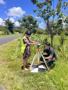
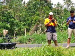
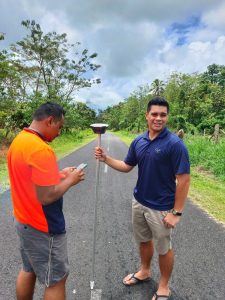
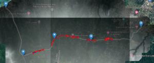
There were 6 priority areas that were highlighted by the team from LTA that we were able to map out using the M300RTK together with collecting Ground Control points for mm precision. From the Orth mosaic our team was able to digitize all above ground assets and also overlay the data that we were able to pull from the SAMS (Samoa Asset Management System).
The tasks undertaken for the Alafa’alava Road Project have provided valuable insights and data crucial for informed decision-making and effective road management. We extend our gratitude to all stakeholders and project partners for collaborating and supporting us throughout this project.
Ecommerce
Grant Disbursement Evoucher System
Client : Government of Samoa Ministry of Agriculture and Fisheries
Project : Samoa Agriculture Fisheries Productivity and Marketing Program Grant Disbursement Project
Year: 2021-2022
The Government of Samoa and World Bank Samoa Agriculture and Fisheries Productivity and Marketing Project (SAFPROM) has a $6.45 million Matching Grant Program (MGP) that aims to increase the productivity and access to market by farmers and fishers. Previously the MGP grants were disbursed manually using physical quotes and purchase orders for farmers and fisher supplies and the process often took between 2 to 4 months causing delays and frustrations for the beneficiaries. Furthermore, some farmers and fishers were purchasing supplies not appropriate for their approved funding. To address these challenges, the Government in 2021 issued a tender for an EVoucher platform to improve the process. The tender was awarded to SkyEye Pacific.
Using SkyEye Pacific’s Maua App EVoucher platform, Farmers and Fishers are issued EVouchers of approved amounts that can only be used to order project pre-approved Products and/or Services from project pre-approved Suppliers. The Farmers and Fishers are able to browse over 20 Suppliers on the Maua App to place their orders from the comfort of their homes or with the assistance from the MAF Matching Grant Funding team. Since the implementation of the EVoucher platform, the disbursement of funds and supplies to Farmers and Fishers have now been completed within 7 days and in some instances within 2 days. To date over $2 million WST has been disbursed to Farmers and Fishers from December 2021 to May 2022 including during full national lockdowns for COVID-19 from March to April 2022.
Maua Payment Gateway
Client: UNCDF and Skyeye Pacific Ltd
Project: UNCDF COVID-19 Response fund to accelerate ecommerce in the Pacific
Year: 2020
Online payments have always been an issue in Samoa because of limited access to bank accounts and credit cards. Businesses of all sizes especially Micro, Small and Medium Enterprises have not been able to access online markets and easy online payment because of the significant requirements for receiving online payment like opening bank accounts overseas. With the Maua Payment Gateway, vendors are able to receive payments via digital wallets and buyers can pay cash or via digital wallets opening up more opportunities for the unbanked.
SkyEye has through funding from UNCDF for COVID-19 response developed the first Pacific specific Payment Gateway that enables vendors of all scales including street vendors, farmers and women road side entrepreneurs to receive payment via Credit Cards locally and internationally without the need for bank accounts and other requirements.
The Maua Payment Gateway also allows three other options of payment which includes cash as well as digital wallets from the local mobile network providers, Digicel and Vodafone available with a merchant portal as well as resources for developers to allow them to integrate into their systems.
Maua Ecommerce Platform/App
Client: Global System for Mobile Communications (GSMA) & Skyeye Pacific Ltd
Project/Award: 2018 GSMA Ecosystem Accelerator Award
Year: 2019
In 2019, SkyEye Pacific with funding and technical assistance from the Global System for Mobile Communications (GSMA) developed and launched Samoa’s 1st localised eCommerce platform, the Maua mobile app. Noting that only 39% of the Samoan population had bank accounts while 72% had mobile phones, a key feature of the Maua platform was the inclusion of Vodafone’s MTala and Digicel’s DMM mobile phone wallets to enable and expand online commerce to the wider public especially those in rural areas without the need for cash payment or a bank account.
The Maua platform provides a full e-commerce ecosystem for buyers and sellers from orders to payment to delivery. By offering the first of its kind ecommerce platform in Samoa and the Pacific, Skeyey through the Maua platform aims to support digital literacy, improve efficiency of market access and business transactions and drive better economic outcomes for local businesses such as retail and especially street vendors, farmers, fishermen, women entrepreneurs, rural populations and persons with disabilities.
Vendors and retailers can now access a shopping and distribution channel with a wider reach and a more efficient sales process with lower overhead costs for their goods and services. A unique feature of the Maua is that each buyer and seller/business will be able to have accurate digital addresses through the SkyEye Ala Addressing system so that sellers and businesses will be able to locate the buyers for delivery of products more efficiently without having to spend inordinate amounts of time on verbal explanations of locations from customers and buyers.
The use of mobile wallets encourages a greater number of users to save money as funds would be secure in their digital wallet. Feedback from some of the Maua vendors shows that having money in digital wallets has reduced spontaneous and unnecessary spending, and that funds have been utilised for essential payments such as water bills, vehicle registration and others.
Farm to Table App – Women in Business
Client: Women in Business Development Incorporated (WIBDI)
Project: Technical Centre for Agricultural and Rural Cooperation (CTA) ICT and food security
Year: 2018
Women in Business Development Incorporated (WIBDI) carries out farm to table operations in which they source organic goods from organic farmers and then sell them to clients either in restaurants, supermarkets or individually. This process requires a lot of manual work in managing the order and client information. With support from the Technical Centre for Agricultural and Rural Cooperation (CTA), WIBDI commissioned SkyEye Pacific to build a Farm to Table App for them to allow easier access to and management of the information for improved planning, monitoring, transactions and reporting.
The Farm to Table App allowed WIBID and their clients to: Load available goods on the app via a google sheet which was for ease of use by non-technical WIBDI staff; view available organic goods and place their orders; and, publish some of their organic farmers’ stories including a listing of companies/vendors that are organically certified.
Geographical Information Systems and Information Management System
MESC Cultural Heritage Site GIS
Client: Samoa Ministry of Education, Sports and Culture (MESC)
Project: Samoa National Cultural Site GIS System
Year: 2021
The Cultural Heritage Unit of the Ministry of Education Sports and Culture (MESC) needed to manage their existing data sheet of Cultural Heritage Sites for Samoa which was stored on separate excel sheets. They needed Cultural Heritage Site information managed in a way that it is easy for MESC staff as well as for Parliamentarians to access the information for their districts with the plan to develop them for tourism purposes.
SkyEye developed a GIS based information System of Samoa cultural heritage sites that allow 3 key things:
- Capture and maintenance of Cultural Heritage Sites information via digital forms with GPS and multimedia data;
- Seamless update of any new data from the field through the electronic field forms directly into the database; and
- Structure all the data with an automatic map atlas in pdf format that is easy for any stakeholder to use.
The resultant system has allowed MECS to capture all their data via their mobile devices without the need to use a dedicated voice recorder for interviews, camera for pictures and a GPS for location. Also the map atlas that is automatically updated when new data is added or changed has helped staff easily service requests from stakeholders including parliamentarians.
Samoa COVID-19 Vulnerable Group Web Database Portal
Client: Samoa Government National Emergency Operating Centre
Project: Mitigating the Effects of COVID-19 Outbreak in Samoa (DFAT funded)
Year: 2021
To support the government’s planned roll out for the COVID 19 vaccines, the focus was on covering the two most vulnerable groups, the over 60 age group as well as those with Non Communicable Diseases (NCDs). In order to do this the Govt of Samoa required 2 things:
- Details of individuals in these two groups; and
- A robust system to store and manage their information.
Working with Kolone Vaai Associates (KVA), we collected the information from the Samoa Bureau of Statistics and other sources and SkyEye built a database and a web portal to manage this information. Features of the database and web portal included:
- User access control with 2 Factor Authentication option;
- Enterprise Grade Relational Database;
- API’s for access as well as input of 3rd party systems information;
- CSV upload feature as there would be more information added later; and
- Web/Cloud based for accessibility and redundancy.
This platform allowed any authorised government staff or stakeholders to access, search, filter individuals information in these vulnerable groups including the option to add their Covid Vaccination Information Dashboard of various statistics such as gender, village, age brackets as well as vaccination status. The Portal also allows automated reporting and other output functions such as pdf and csv output.
National University of Samoa Campus GIS System
Client: National University of Samoa
Project: NUS GIS Planning System
Year: October 2017- March 2018
The Governance, Policy and Planning Division of the National University of Samoa required an asset/ facilities register of NUS facilities/assets as a tool to help provide services as stipulated in the Governance, Policy and Planning Division Service Charter.
SkyEye Pacific developed a GIS System for a centralised portal to capture, store and display/output assets/facilities information which is a key planning tool for the NUS Planning Division. The Planning Division uses this to provide services for both internal and external clients which includes donors, civil engineers, Samoa government, Cabinet and other Ministries.
Skyeye delivered; a NUS Planning Unit GIS System using Open Source tools; Up to date High Resolution Remote Sensing data of NUS Lepapalegalagala; a System Manual; and Training of Planning staff to use the GIS system and the manual.
Samoa Trust Estate Corporation Land Managment Information System (LMIS)
Client: Samoa Trust Estate Corporation
Project: Samoa Trust Estate Corporation Land Management Information System
Year: March-October 2017
The Land Management Information System for STEC was built from the ground up by Skyeye Pacific specifically for the STEC requirements to have the latest Drone Imagery of 6,500 acres of hard-to-access land and digitise in different GIS Layers for various categorisation for STEC use. The system incorporated smartphone based GIS data capturing tools to allow STEC to capture and update the LMIS directly from smartphones to ensure updated information is available to management for decision making.
The digitisation of powerlines by the Electric Power Corporation and waterlines by the Samoa Water Authority and roads by the Land Transport Authority enabled STEC to provide the analysis of the potential usability of different areas of lands for different types of projects.
The main output is a GIS Based Information System for STEC to manage their 6500 acres estate more effectively mapping existing utilised lands, utilities, terrain, forested areas as well as publicly leased land parcels.
Small Business Enterprise ICT and GIS Upgrade
Client: Samoa Small Business Enterprise (SBEC)
Project: SBEC Information Management System
Year: 2016
The Samoa Business Enterprise (SBEC) needed an overhaul of their information management system with a need to upgrade from an MS Access based system to a web based Enterprise system with GIS functions
Working with Browns System Ltd which built the ICT component, SkyEye Pacific built the GIS component for this system to allow SBEC staff to collect projects and clients information from the field via web-forms with geotags. This significantly reduced the paperwork required by SBEC staff working across four islands for their field work since all forms were synced back to the enterprise database.
SBEC were also able to view all their clients’ location and projects on the map which made follow up visits for Monitoring and Evaluation much easier to do.
Smart Tools and Forms for Data Collection and Reporting
Samoa Travel Tracer App
Client: Government of Samoa Tourism Authority
Project: Preparations for COVID 19 border opening
Year: 2021
As part of preparation for eventual opening of Samoa’s international borders in 2020, the Samoa Tourism Authority commissioned Skyeye to develop a Samoa Travel Tracer App that can help trace incoming travellers to Samoa for COVID-19 tracing purposes.
Skyeye worked with the STA, the tourism Industry to adapt the Singapore Tracer App Model to suit Samoan context and realities. For instance, because of the still relatively high cost of the internet in Samoa, the App only requires the use of bluetooth to work and to protect personal information, no names are required for registration, but uses only phone numbers. Only when there is a positive COVID-19 case will the Ministry of Health contact the phone numbers who were within the vicinity of a positive case.
Samoa Measles Mass Vaccination Digital Hub
Client: Government of Samoa and Samoa Information and Technology Association (SITA)
Project: Samoa Measles Mass Vaccination Digital Hub
Year: 3-7 December 2019
At the request of the Samoa Government, SkyEye through the Samoa Information and Technology Association(SITA) voluntarily supported the Digital Hub initiative during the Samoa Measles Mass Vaccination Drive on the 5th and 6th December 2019. The Digital Hub was able to demonstrate how existing information technology tools and expertise in Samoa can assist with digitisation of the measles vaccinations records, provide real time information of progress, generate automatic analytical reports of total numbers including graphs and maps to demonstrate percentage vaccinated by village, district, island and sex. The initiative demonstrated how these tools and national ICT expertise were deployed and the results.
Noting that digital records were only collected from 220 of the 330 villages in Samoa and that not all immunisation teams had digital collection volunteers, the results did not provide the definitive and full vaccination numbers and levels for all of Samoa. The total of submitted digital vaccination forms was for 15,264 people (6,339 were females and 8,925 were males) with 8,200 Geospatial Global Positioning System (GPS) locations. 90% of the forms were from Upolu Island and 10% from Savaii Island.
Key Results
- Live Real Time Data and tracking of progress. Ability to get Live/Real-Time data in Samoa as the vaccination is progressing. This included the ability to track live location and journey travel logs for 55 government vehicles and monitor actual location and progress of mobile teams in real time. Because the reports were automatic and in real time, this initiative demonstrated the ability to minimise the time gap between data collection and reporting/analysis and dissemination. The Prime Minister and Cabinet were able to view on multiple screens automatic reporting on where mobile team vehicles were at, the number of vaccinations as they happen, which district and village was getting most coverage, by age group and sex.
- Automated analysis and dynamic reporting. Automated analysis and dynamic reporting with graphs, charts and maps tracking progress. This enabled leaders to get analysis and reports of percentage of coverage per village, district, island as well as get information on coverage by sex and age groups in real time.
- Recording of actual GPS location of vaccinated population. Digital forms collection enabled recording of actual location of those vaccinated for future follow up through the recording of GPS Locations.
- Minimised data entry errors. Because the data was entered by the same person that was in the field, this minimised data entry errors from different data inputters who have to interpret the handwriting on manually entered paper forms which increases the risk of data errors.
- Reduced overhead costs. Initiative did not require printing and distributing log books, did not require administration people to collate, label, verify, store and then keep track of log books that have been digitized. It also did not need two separate data entry personnel, one in the field and one in the office to input the manual form.
Secured digitised data. Because data is stored in the cloud servers, data is more secure and backed up and less likely to get wet, lost including in times of natural disasters.
Samoa Pilot Programme for Climate Resilience (PPCR) Smart Tools Development for M&E
Client: Samoa Civil Society Support Program (CSSP) through KVA
Project: Samoa Pilot Programme for Climate Resilience (PPCR)
Year: 2019
KVA subcontracted work for the development of smart tools to help them collect data for projects done under the PPCR project. This was not only to help pull all information for the projects together into one central repository but also make it easier for various project stakeholders to access these project M&E information. Smart tools development included:
- Smart forms – Digital forms for collection of project data and submit directly to database without the need for dedicated GPS and Camera
- Smart Database – Google Sheet repository which is easier for stakeholders to use and manage because of spreadsheet familiarity;
- Smart Drone – Web/Online Drone mapping platform made easy for any stakeholder to just upload drone photos and it will process mapping data automatically.
- Smart Maps – Specifically mapping of project data where there are spatial attribute that allows for further spatial analysis like project site proximity to utilities, hazard zones, land tenure etc
- Smart Report – Real time reports from data mined directly from submitted data including existing data in specific views/metrics that is easy for high level officials to understand including dashboard and maps.
- Web Portal – User access control for access to Smart Form, Smart Database, Smart Drone and Smart Reports
Various project data were recorded across multiple implementing agencies from CSSP, to the Ministry of Women, Community and Social Development to the Ministry of Works, Transport and Infrastructure (MWTI) and all the data was wrapped up in Smart Maps and Reports and was presented to the World Bank and stakeholders.
Geospatial Technology / Remote Sensing
Spatial Imagery for Cyclone GITA Post Cyclone Assessment
Client: Samoa Ministry of Natural Resources and Environment and UNDP
Project: Apia Water Catchments Post Tropical Cyclone Gita Assessment.
Year: April-July 2018
Following damage caused by Category 1 Cyclone Gita, the Ministry of Natural Resources (MNRE) through UNDP recruited SkyEye to conduct Spatial Imagery Acquisition to inform their post cyclone assessments and recovery plans. The project was to provide context in the form of spatial imagery and quantifiable data to facilitate investigation into the cause, impacts, and future risks in light of Tropical Cyclone Gita.
SkyEye was asked to provide digital Imagery and Point Cloud Data for 201; provide training of relevant staff in the use of products as a monitoring, assessment and reporting tool and use of SkyEye products for future works; and provide the Project Report on works undertaken, findings, analysis and recommendations.
Skyeye provided the MNRE with a comprehensive report of the drone imagery including analysis and recommendations for future mitigation actions. In 2019, SkyEye received a Technical Excellence Award – SIBA/GITA Asia Pacific award for work on this project.
New Britian Palm Oil Survey and Digital Imagery
Client: New Britain Palm Oil, Solomon Islands
Project: Geospatial Imagery for New Britain Palm Oil, Solomon Islands
Year: July 2016
The project consisted of flying both a fixed wing and quad-propeller Unmanned Aircraft (drones) to take high-resolution photography and GIS Cloud Points of forest/unused land that the customer was earmarking for future development areas for planting as well as identify ecologically important forest areas that are classified to be protected.
Overall, SkyEye surveyed and photographed an estimated area of 130 square kms.
Organic Farm Geocode and Coconut Tree Count
Client: Women in Business Development Incorporated, Samoa
Project: Geospatial Imagery to Count Coconut trees for Organic Farm Geocoding
Year: April 2015 – July 2016
The project consisted of flying both a fixed wing and quad-propeller Unmanned Aircraft (drones) to take high-resolution photography and GIS Cloud Points of organic farms that were registered and certified by WIBD. The data obtained from the drones enabled WIBD to geocode the precise location and the boundary of each farm, but also allow for counting of each coconut on the farms.
SkyEye covered an area of 240 square KMs in both Upolu and Savaii which is equivalent to 10% of the total land mass of Samoa and identified approximately 400,000 coconuts.